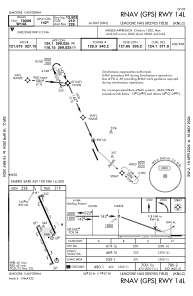
IAC chart of KNLC
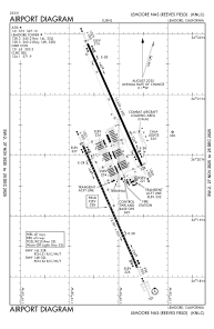
 ADC chart of KNLC
 Satellite view of KNLC

ADC chart of KNLC
Satellite view of KNLC
Sorry, we have no imagery here.
Sorry, we have no imagery here.
Sorry, we have no imagery here.
Sorry, we have no imagery here.
Sorry, we have no imagery here.
Sorry, we have no imagery here.


KNLC - Lemoore Nas (Reeves Fld)
Located in Lemoore, United States
ICAO - NLC, IATA -
Data provided by AirmateGeneral information
Coordinates: N36°19'59" W119°57'8"
Elevation is 228 feet MSL.
Magnetic variation is 14° East View others Airports in California
Operational data
Special qualification required
Current time UTC:
Current local time:
Weather
METAR: KNLC 281956Z 29010KT 10SM SCT049 BKN230 20/06 A3005 RMK AO2 SLP174 RH/40 T02000061
TAF: TAF KNLC 2815/2915 30009KT 9999 FEW070 BKN170 BKN220 QNH3002INS BECMG 2816/2817 34014G21KT 9999 BKN180 BKN230 QNH2991INS TEMPO 2900/2906 34019G29KT SCT220 FM291000 34013G20KT 9999 FEW190 QNH2998INS TX22/2823Z TN08/2913Z FS30067
Communications frequencies: [VIEW]
Runways:
| RWY identifier | QFU | Length (ft) | Width (ft) | Surface | LDA (ft) |
| 14L | 156° | 13502 | 200 | CONC | |
| 32R | 336° | 13502 | 200 | CONC | |
| 14R | 156° | 13501 | 200 | CONC | |
| 32L | 336° | 13501 | 200 | CONC |
Airport contact information
Address: Lemoore United States
Satellite view of KNLC
Sorry, we have no imagery here.
Sorry, we have no imagery here.
Sorry, we have no imagery here.
Sorry, we have no imagery here.
Sorry, we have no imagery here.
Sorry, we have no imagery here.