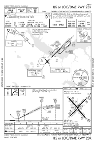
IAC chart of KNKT
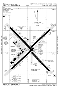
 ADC chart of KNKT
 Satellite view of KNKT
ADC chart of KNKT
Satellite view of KNKT
Sorry, we have no imagery here.
Sorry, we have no imagery here.
Sorry, we have no imagery here.
Sorry, we have no imagery here.
Sorry, we have no imagery here.
Sorry, we have no imagery here.


KNKT - Cherry Point Mcas (Cunningham Fld)
Located in Cherry Point, United States
ICAO - NKT, IATA -
Data provided by AirmateGeneral information
Coordinates: N34°54'11" W76°52'51"
Elevation is 29 feet MSL.
Magnetic variation is -09° East View others Airports in North Carolina
Operational data
Special qualification required
Current time UTC:
Current local time:
Weather
METAR: KNKT 312155Z 19012G18KT 10SM FEW020 26/18 A2976 RMK AO2 SLP076 T02610183
TAF: TAF AMD KNKT 3122/0121 17015G20KT 9999 FEW025 BKN060 542009 542909 543803 QNH2973INS TEMPO 0102/0108 24007G25KT 4800 SHRA BR BKN020 OVC030 BECMG 0108/0110 30009KT 9999 BKN040 500000 QNH2975INS FM011800 02007KT 9999 SCT050 QNH3001INS TX25/3121Z TN19/0111Z AMD 2205Z
Communications frequencies: [VIEW]
Runways:
| RWY identifier | QFU | Length (ft) | Width (ft) | Surface | LDA (ft) |
| 05L | 45° | 8489 | 196 | ASPH | 7554 |
| 23R | 225° | 8489 | 196 | ASPH | 7554 |
| 05R | 45° | 8189 | 200 | ASPH | |
| 23L | 225° | 8189 | 200 | ASPH | |
| 14L | 136° | 8978 | 200 | ASPH | |
| 32R | 316° | 8978 | 200 | ASPH | |
| 14R | 136° | 8397 | 200 | ASPH | 7549 |
| 32L | 316° | 8397 | 200 | ASPH | 7549 |
Airport contact information
Address: Cherry Point United States
Satellite view of KNKT
Sorry, we have no imagery here.
Sorry, we have no imagery here.
Sorry, we have no imagery here.
Sorry, we have no imagery here.
Sorry, we have no imagery here.
Sorry, we have no imagery here.