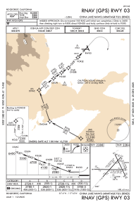
IAC chart of KNID
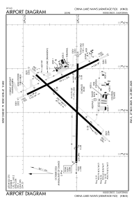
 ADC chart of KNID
 Satellite view of KNID
ADC chart of KNID
Satellite view of KNID
Sorry, we have no imagery here.
Sorry, we have no imagery here.
Sorry, we have no imagery here.
Sorry, we have no imagery here.
Sorry, we have no imagery here.
Sorry, we have no imagery here.


KNID - China Lake Naws (Armitage Fld)
Located in China Lake, United States
ICAO - NID, IATA -
Data provided by AirmateGeneral information
Coordinates: N35°41'7" W117°41'43"
Elevation is 2288 feet MSL.
Magnetic variation is 14° East View others Airports in California
Operational data
Special qualification required
Current time UTC:
Current local time:
Weather
METAR: KNID 180856Z AUTO 26009KT 10SM CLR 17/02 A2984 RMK AO2 SLP090 T01720022 51020 $
Communications frequencies: [VIEW]
Runways:
| RWY identifier | QFU | Length (ft) | Width (ft) | Surface | LDA (ft) |
| 03 | 42° | 10001 | 200 | CONC | |
| 21 | 222° | 10001 | 200 | CONC | |
| 08 | 90° | 11199 | 200 | CONC | |
| 26 | 270° | 11199 | 200 | CONC | |
| 14 | 154° | 9014 | 200 | ASPH | |
| 32 | 334° | 9014 | 200 | ASPH |
Airport contact information
Address: China Lake United States
Satellite view of KNID
Sorry, we have no imagery here.
Sorry, we have no imagery here.
Sorry, we have no imagery here.
Sorry, we have no imagery here.
Sorry, we have no imagery here.
Sorry, we have no imagery here.