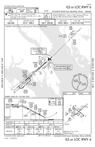
IAC chart of KNHK
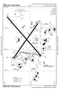
 ADC chart of KNHK
 Satellite view of KNHK
ADC chart of KNHK
Satellite view of KNHK
Sorry, we have no imagery here.
Sorry, we have no imagery here.
Sorry, we have no imagery here.
Sorry, we have no imagery here.
Sorry, we have no imagery here.
Sorry, we have no imagery here.


KNHK - Patuxent River Nas (Trapnell Fld)
Located in Patuxent River, United States
ICAO - NHK, IATA -
Data provided by AirmateGeneral information
Coordinates: N38°17'11" W76°24'36"
Elevation is 38 feet MSL.
Magnetic variation is -10° East View others Airports in Maryland
Operational data
Special qualification required
Current time UTC:
Current local time:
Weather
METAR: KNHK 201952Z 10008KT 10SM SCT130 BKN180 21/10 A2995 RMK AO2 SLP142 T02110100
TAF: TAF KNHK 2015/2115 04010KT 9999 FEW035 BKN250 QNH2992INS BECMG 2020/2021 10006KT 9999 BKN150 BKN250 651509 QNH2990INS BECMG 2101/2103 12008KT 9999 VCSH BKN080 OVC150 651209 652103 QNH2989INS BECMG 2105/2106 11010KT 9999 VCSH FEW025 OVC060 651209 652103 QNH2988INS TEMPO 2106/2111 6000 -RA SCT015 OVC050 BECMG 2109/2111 11014G22KT 3200 RA BR OVC010 651209 652103 QNH2980INS TX22/2020Z TN15/2110Z FN20065
Communications frequencies: [VIEW]
Runways:
| RWY identifier | QFU | Length (ft) | Width (ft) | Surface | LDA (ft) |
| 02 | 8° | 5021 | 75 | ASPH | |
| 20 | 188° | 5021 | 75 | ASPH | |
| 06 | 49° | 11799 | 200 | ASPH | |
| 24 | 229° | 11799 | 200 | ASPH | |
| 14 | 126° | 9732 | 200 | ASPH | |
| 32 | 306° | 9732 | 200 | ASPH |
Airport contact information
Address: Patuxent River United States
Other aviation service providers
Flight schools

Patuxent River Navy Flying Club
Patuxent River Navy Flying Club
pax.flying.club@gmail.com+1(301)862-1110
Satellite view of KNHK
Sorry, we have no imagery here.
Sorry, we have no imagery here.
Sorry, we have no imagery here.
Sorry, we have no imagery here.
Sorry, we have no imagery here.
Sorry, we have no imagery here.