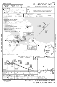
IAC chart of KNGU
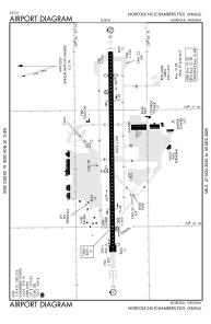
 ADC chart of KNGU
 Satellite view of KNGU

ADC chart of KNGU
Satellite view of KNGU
Sorry, we have no imagery here.
Sorry, we have no imagery here.
Sorry, we have no imagery here.
Sorry, we have no imagery here.
Sorry, we have no imagery here.
Sorry, we have no imagery here.


KNGU - Norfolk Ns (Chambers Fld)
Located in Norfolk, United States
ICAO - NGU, IATA -
Data provided by AirmateGeneral information
Coordinates: N36°56'15" W76°17'21"
Elevation is 14 feet MSL.
Magnetic variation is -10° East View others Airports in Virginia
Operational data
Special qualification required
Current time UTC:
Current local time:
Weather
METAR: KNGU 180459Z 32016G25KT 10SM SCT120 08/M02 A3005 RMK AO2 PK WND 34029/0412 SLP176 T00831017 402110083
TAF: TAF KNGU 1723/1823 36020G32KT 9999 FEW020 BKN050 QNH2988INS BECMG 1806/1808 33015G25KT 9999 SKC QNH2999INS BECMG 1815/1817 34011KT 9999 SKC QNH3007INS TX17/1818Z TN04/1812Z FN20079
Communications frequencies: [VIEW]
Runways:
| RWY identifier | QFU | Length (ft) | Width (ft) | Surface | LDA (ft) |
| 10 | 90° | 8370 | 200 | ASPH | 8071 |
| 28 | 270° | 8370 | 200 | ASPH | 7375 |
Airport contact information
Address: Norfolk United States
Satellite view of KNGU
Sorry, we have no imagery here.
Sorry, we have no imagery here.
Sorry, we have no imagery here.
Sorry, we have no imagery here.
Sorry, we have no imagery here.
Sorry, we have no imagery here.