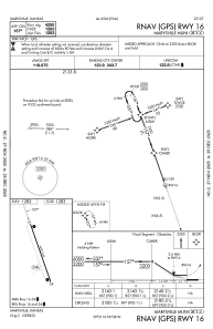
IAC chart of KMYZ
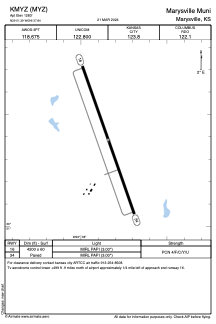
 ADC chart of KMYZ
 Satellite view of KMYZ
ADC chart of KMYZ
Satellite view of KMYZ
Sorry, we have no imagery here.
Sorry, we have no imagery here.
Sorry, we have no imagery here.
Sorry, we have no imagery here.
Sorry, we have no imagery here.
Sorry, we have no imagery here.


KMYZ - Marysville Muni
Located in Marysville, United States
ICAO - MYZ, IATA -
Data provided by AirmateGeneral information
Coordinates: N39°51'23" W96°37'51"
Elevation is 1283 feet MSL.
Magnetic variation is 04° East View others Airports in Kansas
Operational data
Special qualification required
Current time UTC:
Current local time:
Weather
METAR: KMYZ 170055Z AUTO 15005KT 10SM CLR 09/M12 A2998 RMK AO2
Communications frequencies: [VIEW]
Runways:
| RWY identifier | QFU | Length (ft) | Width (ft) | Surface | LDA (ft) |
| 16 | 161° | 4200 | 60 | ASPH | |
| 34 | 341° | 4200 | 60 | ASPH | |
| H1 | 0° | 0 | 0 | UNK |
Airport contact information
Address: Marysville United States
Satellite view of KMYZ
Sorry, we have no imagery here.
Sorry, we have no imagery here.
Sorry, we have no imagery here.
Sorry, we have no imagery here.
Sorry, we have no imagery here.
Sorry, we have no imagery here.