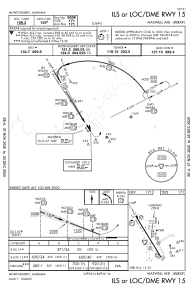
IAC chart of KMXF
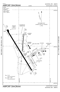
 ADC chart of KMXF
 Satellite view of KMXF
ADC chart of KMXF
Satellite view of KMXF
Sorry, we have no imagery here.
Sorry, we have no imagery here.
Sorry, we have no imagery here.
Sorry, we have no imagery here.
Sorry, we have no imagery here.
Sorry, we have no imagery here.


KMXF - Maxwell Afb
Located in Montgomery, United States
ICAO - MXF, IATA -
Data provided by AirmateGeneral information
Coordinates: N32°22'59" W86°21'57"
Elevation is 170 feet MSL.
Magnetic variation is -02° East View others Airports in Alabama
Operational data
Special qualification required
Current time UTC:
Current local time:
Weather
METAR: KMXF 240255Z AUTO 00000KT 10SM CLR 23/20 A3003 RMK AO2 SLP170 T02310196 52010
TAF: TAF KMXF 231910Z 2319/2501 VRB06KT 9999 FEW060 QNH3002INS TX32/2321Z TN19/2411Z LAST NO AMDS AFT 2403 NEXT 2411
Communications frequencies: [VIEW]
Runways:
| RWY identifier | QFU | Length (ft) | Width (ft) | Surface | LDA (ft) |
| 009 | 0° | 3015 | 60 | ASPH | |
| 189 | 0° | 3015 | 60 | ASPH | |
| 15 | 148° | 8008 | 150 | ASPH | |
| 33 | 328° | 8008 | 150 | ASPH |
Airport contact information
Address: Montgomery United States
Satellite view of KMXF
Sorry, we have no imagery here.
Sorry, we have no imagery here.
Sorry, we have no imagery here.
Sorry, we have no imagery here.
Sorry, we have no imagery here.
Sorry, we have no imagery here.