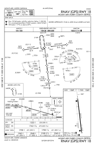
IAC chart of KMWK
 Satellite view of KMWK
Satellite view of KMWK
Sorry, we have no imagery here.
Sorry, we have no imagery here.


KMWK - Mount Airy/Surry County
Located in Mount Airy, United States
ICAO - MWK, IATA -
Data provided by AirmateGeneral information
Coordinates: N36°27'41" W80°33'12"
Elevation is 1268 feet MSL.
Magnetic variation is -07° East View others Airports in North Carolina
Operational data
Special qualification required
Current time UTC:
Current local time:
Communications frequencies: [VIEW]
Runways:
| RWY identifier | QFU | Length (ft) | Width (ft) | Surface | LDA (ft) |
| 18 | 173° | 5500 | 75 | ASPH | |
| 36 | 353° | 5500 | 75 | ASPH |
Airport contact information
Address: Mount Airy United States
Other aviation service providers
Flight schools

Satellite view of KMWK
Sorry, we have no imagery here.
Sorry, we have no imagery here.