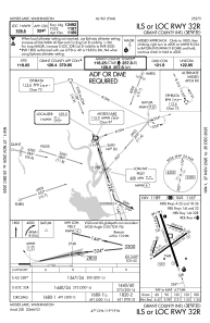
IAC chart of KMWH
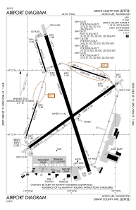
 ADC chart of KMWH
 Satellite view of KMWH
ADC chart of KMWH
Satellite view of KMWH
Sorry, we have no imagery here.
Sorry, we have no imagery here.
Sorry, we have no imagery here.
Sorry, we have no imagery here.
Sorry, we have no imagery here.
Sorry, we have no imagery here.


KMWH - Grant County Intl
Located in Moses Lake, United States
ICAO - MWH, IATA - MWH
Data provided by AirmateGeneral information
Coordinates: N47°12'31" W119°19'9"
Elevation is 1188 feet MSL.
Magnetic variation is 18° East View others Airports in Washington
Operational data
Special qualification required
Current time UTC:
Current local time:
Weather
METAR: KMWH 170752Z AUTO 00000KT 10SM CLR 01/M03 A2973 RMK AO2 SLP075 T00061033 401110000
TAF: KMWH 170520Z 1706/1806 26008KT P6SM FEW090 SCT200 FM171200 28004KT P6SM BKN080 FM172000 27009KT P6SM FEW070 SCT110
Communications frequencies: [VIEW]
Runways:
| RWY identifier | QFU | Length (ft) | Width (ft) | Surface | LDA (ft) |
| 04 | 54° | 10000 | 100 | CONC | 10000 |
| 22 | 234° | 10000 | 100 | CONC | 10000 |
| 09 | 108° | 3500 | 90 | CONC | 3500 |
| 27 | 288° | 3500 | 90 | CONC | 3500 |
| 14L | 162° | 13503 | 200 | CONC | 13503 |
| 32R | 342° | 13503 | 200 | CONC | 13492 |
| 14R | 162° | 2936 | 75 | CONC | 2936 |
| 32L | 342° | 2936 | 75 | CONC | 2936 |
| 18 | 198° | 3327 | 75 | ASPH | |
| 36 | 18° | 3327 | 75 | ASPH | |
| H1 | 0° | 0 | 0 | UNK | |
| H2 | 0° | 0 | 0 | UNK |
Airport contact information
Address: Moses Lake United States
Other aviation service providers
Flight schools

Satellite view of KMWH
Sorry, we have no imagery here.
Sorry, we have no imagery here.
Sorry, we have no imagery here.
Sorry, we have no imagery here.
Sorry, we have no imagery here.
Sorry, we have no imagery here.