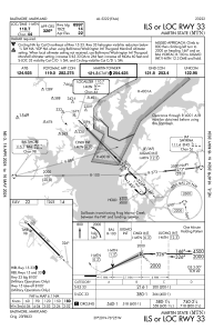
IAC chart of KMTN
 ADC chart of KMTN
 Satellite view of KMTN
ADC chart of KMTN
Satellite view of KMTN
Sorry, we have no imagery here.
Sorry, we have no imagery here.
Sorry, we have no imagery here.
Sorry, we have no imagery here.
Sorry, we have no imagery here.
Sorry, we have no imagery here.


KMTN - Martin State
Located in Baltimore, United States
ICAO - MTN, IATA -
Data provided by AirmateGeneral information
Coordinates: N39°19'32" W76°24'50"
Elevation is 21 feet MSL.
Magnetic variation is -11° East View others Airports in Maryland
Operational data
Special qualification required
Current time UTC:
Current local time:
Weather
METAR: KMTN 300229Z AUTO 00000KT 10SM CLR 17/10 A3007 RMK AO2
Communications frequencies: [VIEW]
Runways:
| RWY identifier | QFU | Length (ft) | Width (ft) | Surface | LDA (ft) |
| 15 | 135° | 6997 | 180 | ASPH | |
| 33 | 315° | 6997 | 180 | ASPH | |
| H1 | 0° | 0 | 0 | UNK |
Airport contact information
Address: Baltimore United States
Other aviation service providers
Repair station

Flight schools

Satellite view of KMTN
Sorry, we have no imagery here.
Sorry, we have no imagery here.
Sorry, we have no imagery here.
Sorry, we have no imagery here.
Sorry, we have no imagery here.
Sorry, we have no imagery here.