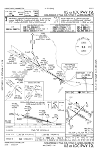
IAC chart of KMSP
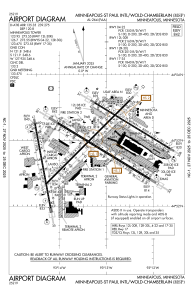
 ADC chart of KMSP
 Satellite view of KMSP
ADC chart of KMSP
Satellite view of KMSP
Sorry, we have no imagery here.
Sorry, we have no imagery here.
Sorry, we have no imagery here.
Sorry, we have no imagery here.
Sorry, we have no imagery here.
Sorry, we have no imagery here.


KMSP - Minneapolis-St Paul Intl/Wold-Chamberlain
Located in Minneapolis, United States
ICAO - MSP, IATA - MSP
Data provided by AirmateGeneral information
Coordinates: N44°52'55" W93°13'18"
Elevation is 841 feet MSL.
Magnetic variation is 00° East View others Airports in Minnesota
Operational data
Special qualification required
Current time UTC:
Current local time:
Weather
METAR: KMSP 201053Z 08016G26KT 5SM RA BR SCT014 BKN034 OVC070 08/06 A2974 RMK AO2 PK WND 09026/1034 PRESFR SLP074 P0013 T00780061
TAF: KMSP 200909Z 2009/2112 09017G27KT 6SM -RA BR OVC060 FM201000 09021G33KT 4SM -RA BR OVC020 FM201800 08020G32KT 3SM -RA BR OVC010 FM210200 07014G24KT 3SM -RA BR OVC008
Communications frequencies: [VIEW]
Runways:
| RWY identifier | QFU | Length (ft) | Width (ft) | Surface | LDA (ft) |
| 04 | 45° | 11006 | 150 | CONC | 9456 |
| 22 | 225° | 11006 | 150 | CONC | 10006 |
| 12L | 121° | 8200 | 150 | CONC | 7620 |
| 30R | 301° | 8200 | 150 | CONC | 8000 |
| 12R | 121° | 10000 | 200 | CONC | 10000 |
| 30L | 301° | 10000 | 200 | CONC | 10000 |
| 17 | 170° | 8000 | 150 | CONC | 8000 |
| 35 | 350° | 8000 | 150 | CONC | 8000 |
Airport contact information
Address: Minneapolis United States
Other aviation service providers
Repair station

Satellite view of KMSP
Sorry, we have no imagery here.
Sorry, we have no imagery here.
Sorry, we have no imagery here.
Sorry, we have no imagery here.
Sorry, we have no imagery here.
Sorry, we have no imagery here.