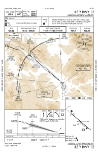
IAC chart of KMSO
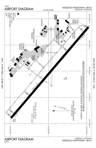
 ADC chart of KMSO
 Satellite view of KMSO

ADC chart of KMSO
Satellite view of KMSO
Sorry, we have no imagery here.
Sorry, we have no imagery here.
Sorry, we have no imagery here.
Sorry, we have no imagery here.
Sorry, we have no imagery here.
Sorry, we have no imagery here.


KMSO - Missoula Montana
Located in Missoula, United States
ICAO - MSO, IATA - MSO
Data provided by AirmateGeneral information
Coordinates: N46°54'59" W114°5'26"
Elevation is 3205 feet MSL.
Magnetic variation is 13° East View others Airports in Montana
Operational data
Special qualification required
Current time UTC:
Current local time:
Weather
METAR: KMSO 150753Z AUTO 28003KT 10SM FEW039 BKN055 OVC070 01/M02 A2957 RMK AO2 SLP031 T00061022
TAF: KMSO 150529Z 1506/1606 33003KT P6SM BKN050 PROB30 1506/1510 6SM -SHSN OVC030 FM151700 17003KT P6SM OVC040 PROB30 1517/1519 4SM -SHSN OVC030 FM152000 26011KT P6SM OVC050 FM152100 28017G27KT P6SM OVC050
Communications frequencies: [VIEW]
Runways:
| RWY identifier | QFU | Length (ft) | Width (ft) | Surface | LDA (ft) |
| 08 | 89° | 4612 | 75 | ASPH | 4612 |
| 26 | 269° | 4612 | 75 | ASPH | 4612 |
| 12 | 130° | 9501 | 150 | ASPH | 9501 |
| 30 | 310° | 9501 | 150 | ASPH | 9501 |
Airport contact information
Address: Missoula United States
Other aviation service providers
Repair station

Flight schools

Satellite view of KMSO
Sorry, we have no imagery here.
Sorry, we have no imagery here.
Sorry, we have no imagery here.
Sorry, we have no imagery here.
Sorry, we have no imagery here.
Sorry, we have no imagery here.