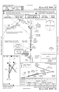
IAC chart of KMSN
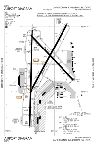
 ADC chart of KMSN
 Satellite view of KMSN
ADC chart of KMSN
Satellite view of KMSN
Sorry, we have no imagery here.
Sorry, we have no imagery here.
Sorry, we have no imagery here.
Sorry, we have no imagery here.
Sorry, we have no imagery here.
Sorry, we have no imagery here.


KMSN - Dane County Rgnl/Truax Fld
Located in Madison, United States
ICAO - MSN, IATA - MSN
Data provided by AirmateGeneral information
Coordinates: N43°8'24" W89°20'15"
Elevation is 886 feet MSL.
Magnetic variation is -03° East View others Airports in Wisconsin
Operational data
Special qualification required
Current time UTC:
Current local time:
Weather
METAR: KMSN 061953Z 22007KT 190V250 10SM SCT250 09/M09 A3003 RMK AO2 SLP175 T00941089
TAF: KMSN 061735Z 0618/0718 25005KT P6SM SKC FM070400 23007KT P6SM FEW140 WS020/25040KT FM070600 25008KT P6SM FEW050 SCT100 FM070800 34009KT P6SM BKN045 PROB30 0708/0709 4SM -SHSN OVC025 FM070900 35010G19KT 6SM -SHSN BKN035 FM071000 35010G20KT P6SM BKN035 PROB30 0710/0711 4SM -SHSN OVC025
Communications frequencies: [VIEW]
Runways:
| RWY identifier | QFU | Length (ft) | Width (ft) | Surface | LDA (ft) |
| 03 | 29° | 7200 | 150 | CONC | 6770 |
| 21 | 209° | 7200 | 150 | CONC | 7015 |
| 14 | 136° | 5846 | 150 | CONC | 5369 |
| 32 | 316° | 5846 | 150 | CONC | 5846 |
| 18 | 182° | 9006 | 150 | CONC | 8606 |
| 36 | 2° | 9006 | 150 | CONC | 8006 |
Airport contact information
Address: Madison United States

Satellite view of KMSN
Sorry, we have no imagery here.
Sorry, we have no imagery here.
Sorry, we have no imagery here.
Sorry, we have no imagery here.
Sorry, we have no imagery here.
Sorry, we have no imagery here.