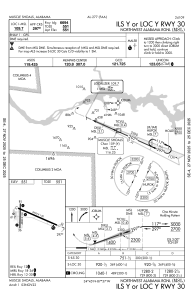
IAC chart of KMSL
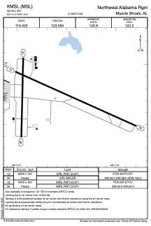
 ADC chart of KMSL
 Satellite view of KMSL

ADC chart of KMSL
Satellite view of KMSL
Sorry, we have no imagery here.
Sorry, we have no imagery here.
Sorry, we have no imagery here.
Sorry, we have no imagery here.
Sorry, we have no imagery here.
Sorry, we have no imagery here.


KMSL - Northwest Alabama Rgnl
Located in Muscle Shoals, United States
ICAO - MSL, IATA - MSL
Data provided by AirmateGeneral information
Coordinates: N34°44'43" W87°36'37"
Elevation is 550 feet MSL.
Magnetic variation is -03° East View others Airports in Alabama
Operational data
Special qualification required
Current time UTC:
Current local time:
Weather
METAR: KMSL 172353Z AUTO 00000KT 10SM CLR 06/M06 A3023 RMK AO2 SLP240 T00561056 10072 20039 56008 $
TAF: KMSL 172320Z 1800/1824 04003KT P6SM FEW250 FM181600 05007KT P6SM BKN220
Communications frequencies: [VIEW]
Runways:
| RWY identifier | QFU | Length (ft) | Width (ft) | Surface | LDA (ft) |
| 12 | 114° | 6694 | 150 | ASPH | |
| 30 | 294° | 6694 | 150 | ASPH | |
| 18 | 181° | 4000 | 100 | ASPH | |
| 36 | 1° | 4000 | 100 | ASPH |
Airport contact information
Address: Muscle Shoals United States
Satellite view of KMSL
Sorry, we have no imagery here.
Sorry, we have no imagery here.
Sorry, we have no imagery here.
Sorry, we have no imagery here.
Sorry, we have no imagery here.
Sorry, we have no imagery here.