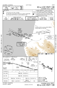
IAC chart of KMRY
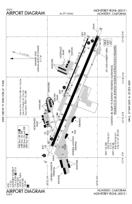
 ADC chart of KMRY
 Satellite view of KMRY
ADC chart of KMRY
Satellite view of KMRY
Sorry, we have no imagery here.
Sorry, we have no imagery here.
Sorry, we have no imagery here.
Sorry, we have no imagery here.
Sorry, we have no imagery here.
Sorry, we have no imagery here.


KMRY - Monterey Rgnl
Located in Monterey, United States
ICAO - MRY, IATA - MRY
Data provided by AirmateGeneral information
Coordinates: N36°35'13" W121°50'34"
Elevation is 256 feet MSL.
Magnetic variation is 15° East View others Airports in California
Operational data
Special qualification required
Current time UTC:
Current local time:
Weather
METAR: KMRY 151854Z 30004KT 10SM OVC017 14/11 A3006 RMK AO2 SLP192 T01390111
TAF: KMRY 151730Z 1518/1618 VRB03KT P6SM OVC010 FM151930 24012KT P6SM FEW012 BKN150 FM160200 24006KT P6SM SCT012 BKN150 FM160700 18004KT P6SM BKN012
Communications frequencies: [VIEW]
Runways:
| RWY identifier | QFU | Length (ft) | Width (ft) | Surface | LDA (ft) |
| 10L | 113° | 3503 | 60 | ASPH | |
| 28R | 293° | 3503 | 60 | ASPH | |
| 10R | 113° | 7175 | 150 | ASPH | 7000 |
| 28L | 293° | 7175 | 150 | ASPH | 7000 |
Airport contact information
Address: Monterey United States
Other aviation service providers
Flight schools

Aerodynamic Aviation - Monterey
Aerodynamic Aviation - Monterey
info@aerodynamicaviation.com+1(831)240-0800
Satellite view of KMRY
Sorry, we have no imagery here.
Sorry, we have no imagery here.
Sorry, we have no imagery here.
Sorry, we have no imagery here.
Sorry, we have no imagery here.
Sorry, we have no imagery here.