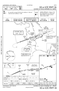
IAC chart of KMRB
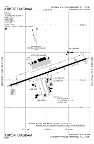
 ADC chart of KMRB
 Satellite view of KMRB
ADC chart of KMRB
Satellite view of KMRB
Sorry, we have no imagery here.
Sorry, we have no imagery here.
Sorry, we have no imagery here.
Sorry, we have no imagery here.
Sorry, we have no imagery here.
Sorry, we have no imagery here.


KMRB - Eastern Wv Rgnl/Shepherd Fld
Located in Martinsburg, United States
ICAO - MRB, IATA - MRB
Data provided by AirmateGeneral information
Coordinates: N39°24'8" W77°58'59"
Elevation is 564 feet MSL.
Magnetic variation is -08° East View others Airports in West Virginia
Operational data
Special qualification required
Current time UTC:
Current local time:
Weather
METAR: KMRB 302253Z 17004KT 10SM CLR 32/22 A2994 RMK AO2 SLP131 T03170222
TAF: KMRB 301725Z 3018/3118 16006KT P6SM VCSH SCT040 SCT250 FM310100 18002KT P6SM FEW060 BKN250 FM310800 00000KT 4SM BR SCT003 BKN200 FM311200 VRB02KT P6SM SCT025 BKN200 FM311500 VRB05KT P6SM VCSH SCT035 BKN150
Communications frequencies: [VIEW]
Runways:
| RWY identifier | QFU | Length (ft) | Width (ft) | Surface | LDA (ft) |
| 08 | 71° | 8815 | 150 | OTHER | 8215 |
| 26 | 251° | 8815 | 150 | OTHER | 7815 |
Airport contact information
Address: Martinsburg United States
Other aviation service providers
Flight schools

Satellite view of KMRB
Sorry, we have no imagery here.
Sorry, we have no imagery here.
Sorry, we have no imagery here.
Sorry, we have no imagery here.
Sorry, we have no imagery here.
Sorry, we have no imagery here.