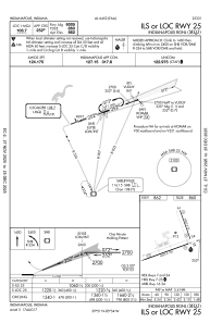
IAC chart of KMQJ
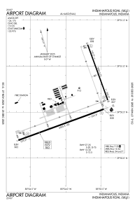
 ADC chart of KMQJ
 Satellite view of KMQJ
ADC chart of KMQJ
Satellite view of KMQJ
Sorry, we have no imagery here.
Sorry, we have no imagery here.
Sorry, we have no imagery here.
Sorry, we have no imagery here.
Sorry, we have no imagery here.
Sorry, we have no imagery here.


KMQJ - Indianapolis Rgnl
Located in Indianapolis, United States
ICAO - MQJ, IATA -
Data provided by AirmateGeneral information
Coordinates: N39°50'35" W85°53'52"
Elevation is 862 feet MSL.
Magnetic variation is -02° East View others Airports in Indiana
Operational data
Special qualification required
Current time UTC:
Current local time:
Weather
METAR: KMQJ 282335Z AUTO 23020G32KT 9SM BKN110 24/08 A2993 RMK AO2 PK WND 22032/2329 T02420084 $
Communications frequencies: [VIEW]
Runways:
| RWY identifier | QFU | Length (ft) | Width (ft) | Surface | LDA (ft) |
| 07 | 70° | 6005 | 100 | ASPH | |
| 25 | 250° | 6005 | 100 | ASPH | |
| 16 | 160° | 3902 | 75 | CONC | |
| 34 | 340° | 3902 | 75 | CONC |
Airport contact information
Address: Indianapolis United States
Other aviation service providers
Repair station

Flight schools

Satellite view of KMQJ
Sorry, we have no imagery here.
Sorry, we have no imagery here.
Sorry, we have no imagery here.
Sorry, we have no imagery here.
Sorry, we have no imagery here.
Sorry, we have no imagery here.