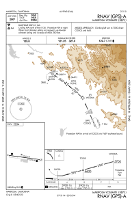
IAC chart of KMPI
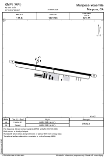
 ADC chart of KMPI
 Satellite view of KMPI

ADC chart of KMPI
Satellite view of KMPI
Sorry, we have no imagery here.
Sorry, we have no imagery here.
Sorry, we have no imagery here.
Sorry, we have no imagery here.
Sorry, we have no imagery here.
Sorry, we have no imagery here.


KMPI - Mariposa-Yosemite
Located in Mariposa, United States
ICAO - MPI, IATA - RMY
Data provided by AirmateGeneral information
Coordinates: N37°30'39" W120°2'22"
Elevation is 2254 feet MSL.
Magnetic variation is 15° East View others Airports in California
Operational data
Special qualification required
Current time UTC:
Current local time:
Weather at : KMCE - Merced Yosemite Rgnl ( 49 km )
TAF: KMCE 162320Z 1700/1724 15007KT P6SM FEW050 BKN150 FM171000 14010KT P6SM -RA OVC050 FM171600 30012KT P6SM -SHRA SCT030 BKN050
Communications frequencies: [VIEW]
Runways:
| RWY identifier | QFU | Length (ft) | Width (ft) | Surface | LDA (ft) |
| 08 | 100° | 3305 | 60 | ASPH | |
| 26 | 280° | 3305 | 60 | ASPH |
Airport contact information
Address: Mariposa United States
Other aviation service providers
Flight schools

Airborrn Aviation Services, Llc
Airborrn Aviation Services, Llc
airborrnaviation@gmail.com+1(209)966-2143
Satellite view of KMPI
Sorry, we have no imagery here.
Sorry, we have no imagery here.
Sorry, we have no imagery here.
Sorry, we have no imagery here.
Sorry, we have no imagery here.
Sorry, we have no imagery here.