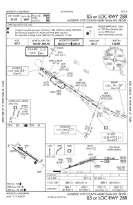
IAC chart of KMOD
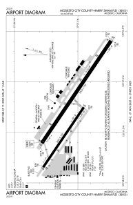
 ADC chart of KMOD
 Satellite view of KMOD
ADC chart of KMOD
Satellite view of KMOD
Sorry, we have no imagery here.
Sorry, we have no imagery here.
Sorry, we have no imagery here.
Sorry, we have no imagery here.
Sorry, we have no imagery here.
Sorry, we have no imagery here.


KMOD - Modesto City-County-Harry Sham Fld
Located in Modesto, United States
ICAO - MOD, IATA - MOD
Data provided by AirmateGeneral information
Coordinates: N37°37'33" W120°57'16"
Elevation is 99 feet MSL.
Magnetic variation is 16° East View others Airports in California
Operational data
Special qualification required
Current time UTC:
Current local time:
Weather
TAF: KMOD 041720Z 0418/0518 32005KT P6SM SKC FM042100 32014G21KT P6SM SKC FM050600 34010KT P6SM SKC
Communications frequencies: [VIEW]
Runways:
| RWY identifier | QFU | Length (ft) | Width (ft) | Surface | LDA (ft) |
| 10L | 124° | 5904 | 150 | ASPH | 5904 |
| 28R | 304° | 5904 | 150 | ASPH | 5904 |
| 10R | 124° | 3464 | 100 | ASPH | 3464 |
| 28L | 304° | 3464 | 100 | ASPH | 3464 |
Airport contact information
Address: Modesto United States
Other aviation service providers
Repair station

Satellite view of KMOD
Sorry, we have no imagery here.
Sorry, we have no imagery here.
Sorry, we have no imagery here.
Sorry, we have no imagery here.
Sorry, we have no imagery here.
Sorry, we have no imagery here.