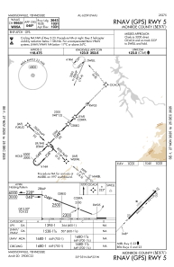
IAC chart of KMNV
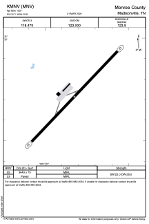
 ADC chart of KMNV
 Satellite view of KMNV
ADC chart of KMNV
Satellite view of KMNV
Sorry, we have no imagery here.
Sorry, we have no imagery here.
Sorry, we have no imagery here.
Sorry, we have no imagery here.
Sorry, we have no imagery here.
Sorry, we have no imagery here.


KMNV - Monroe County
Located in Madisonville, United States
ICAO - MNV, IATA -
Data provided by AirmateGeneral information
Coordinates: N35°32'43" W84°22'49"
Elevation is 1031 feet MSL.
Magnetic variation is -04° East View others Airports in Tennessee
Operational data
Special qualification required
Current time UTC:
Current local time:
Weather
METAR: KMNV 041815Z AUTO 25006KT 10SM FEW021 FEW028 OVC042 24/21 A3010 RMK A01
Communications frequencies: [VIEW]
Runways:
| RWY identifier | QFU | Length (ft) | Width (ft) | Surface | LDA (ft) |
| 05 | 44° | 3643 | 75 | ASPH | |
| 23 | 224° | 3643 | 75 | ASPH |
Airport contact information
Address: Madisonville United States
Satellite view of KMNV
Sorry, we have no imagery here.
Sorry, we have no imagery here.
Sorry, we have no imagery here.
Sorry, we have no imagery here.
Sorry, we have no imagery here.
Sorry, we have no imagery here.