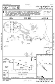
IAC chart of KMLT
 Satellite view of KMLT
Satellite view of KMLT
Sorry, we have no imagery here.
Sorry, we have no imagery here.
Sorry, we have no imagery here.
Sorry, we have no imagery here.
Sorry, we have no imagery here.
Sorry, we have no imagery here.


KMLT - Millinocket Muni
Located in Millinocket, United States
ICAO - MLT, IATA -
Data provided by AirmateGeneral information
Coordinates: N45°38'52" W68°41'8"
Elevation is 408 feet MSL.
Magnetic variation is -17° East View others Airports in Maine
Operational data
Special qualification required
Current time UTC:
Current local time:
Weather
METAR: KMLT 180009Z AUTO 14005KT 3SM BR OVC006 13/12 A2958 RMK AO2 T01280122
Communications frequencies: [VIEW]
Runways:
| RWY identifier | QFU | Length (ft) | Width (ft) | Surface | LDA (ft) |
| 11 | 90° | 4713 | 99 | ASPH | |
| 29 | 270° | 4713 | 99 | ASPH | |
| 16 | 139° | 4000 | 100 | ASPH | |
| 34 | 319° | 4000 | 100 | ASPH |
Airport contact information
Address: Millinocket United States
Satellite view of KMLT
Sorry, we have no imagery here.
Sorry, we have no imagery here.
Sorry, we have no imagery here.
Sorry, we have no imagery here.
Sorry, we have no imagery here.
Sorry, we have no imagery here.