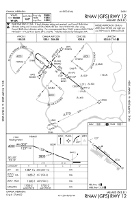
IAC chart of KMLE
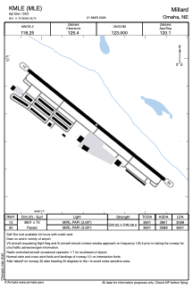
 ADC chart of KMLE
 Satellite view of KMLE
ADC chart of KMLE
Satellite view of KMLE
Sorry, we have no imagery here.
Sorry, we have no imagery here.
Sorry, we have no imagery here.
Sorry, we have no imagery here.
Sorry, we have no imagery here.
Sorry, we have no imagery here.


KMLE - Millard
Located in Omaha, United States
ICAO - MLE, IATA -
Data provided by AirmateGeneral information
Coordinates: N41°11'46" W96°6'44"
Elevation is 1050 feet MSL.
Magnetic variation is 06° East View others Airports in Nebraska
Operational data
Special qualification required
Current time UTC:
Current local time:
Weather
METAR: KMLE 092155Z AUTO 36008KT 340V040 10SM BKN090 23/01 A2991 RMK AO2 T02270011
Communications frequencies: [VIEW]
Runways:
| RWY identifier | QFU | Length (ft) | Width (ft) | Surface | LDA (ft) |
| 12 | 129° | 3801 | 75 | ASPH | 3588 |
| 30 | 309° | 3801 | 75 | ASPH | 3801 |
Airport contact information
Address: Omaha United States
Other aviation service providers
Repair station

Satellite view of KMLE
Sorry, we have no imagery here.
Sorry, we have no imagery here.
Sorry, we have no imagery here.
Sorry, we have no imagery here.
Sorry, we have no imagery here.
Sorry, we have no imagery here.