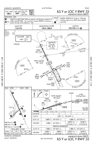
IAC chart of KMKT
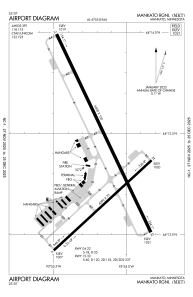
 ADC chart of KMKT
 Satellite view of KMKT
ADC chart of KMKT
Satellite view of KMKT
Sorry, we have no imagery here.
Sorry, we have no imagery here.
Sorry, we have no imagery here.
Sorry, we have no imagery here.
Sorry, we have no imagery here.
Sorry, we have no imagery here.


KMKT - Mankato Rgnl
Located in Mankato, United States
ICAO - MKT, IATA -
Data provided by AirmateGeneral information
Coordinates: N44°13'22" W93°55'10"
Elevation is 1020 feet MSL.
Magnetic variation is 00° East View others Airports in Minnesota
Operational data
Special qualification required
Current time UTC:
Current local time:
Weather
METAR: KMKT 191256Z AUTO 09014KT 10SM SCT110 07/04 A2998 RMK AO2 SLP158 T00720039
TAF: KMKT 191120Z 1912/2012 06012G20KT P6SM BKN250 FM191400 09018G27KT 6SM -SHRA BR OVC100 FM192100 10021G30KT 6SM -SHRA BR BKN030 FM200100 10019G31KT 6SM -SHRA BR OVC025 PROB30 2001/2005 4SM -TSRA OVC025CB
Communications frequencies: [VIEW]
Runways:
| RWY identifier | QFU | Length (ft) | Width (ft) | Surface | LDA (ft) |
| 04 | 47° | 4000 | 75 | ASPH | |
| 22 | 227° | 4000 | 75 | ASPH | |
| 15 | 155° | 6600 | 100 | CONC | |
| 33 | 335° | 6600 | 100 | CONC |
Airport contact information
Address: Mankato United States
Other aviation service providers
Repair station

Flight schools

Satellite view of KMKT
Sorry, we have no imagery here.
Sorry, we have no imagery here.
Sorry, we have no imagery here.
Sorry, we have no imagery here.
Sorry, we have no imagery here.
Sorry, we have no imagery here.