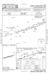
IAC chart of KMKJ
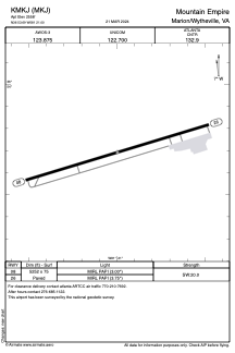
 ADC chart of KMKJ
 Satellite view of KMKJ
ADC chart of KMKJ
Satellite view of KMKJ
Sorry, we have no imagery here.
Sorry, we have no imagery here.
Sorry, we have no imagery here.
Sorry, we have no imagery here.
Sorry, we have no imagery here.
Sorry, we have no imagery here.


KMKJ - Mountain Empire
Located in Marion/Wytheville, United States
ICAO - MKJ, IATA -
Data provided by AirmateGeneral information
Coordinates: N36°53'41" W81°20'60"
Elevation is 2558 feet MSL.
Magnetic variation is -06° East View others Airports in Virginia
Operational data
Special qualification required
Current time UTC:
Current local time:
Weather
METAR: KMKJ 290135Z AUTO 00000KT 10SM SCT060 OVC075 16/16 A3015 RMK AO2 T01640164
Communications frequencies: [VIEW]
Runways:
| RWY identifier | QFU | Length (ft) | Width (ft) | Surface | LDA (ft) |
| 08 | 73° | 5252 | 75 | ASPH | |
| 26 | 253° | 5252 | 75 | ASPH |
Airport contact information
Address: Marion/Wytheville United States
Satellite view of KMKJ
Sorry, we have no imagery here.
Sorry, we have no imagery here.
Sorry, we have no imagery here.
Sorry, we have no imagery here.
Sorry, we have no imagery here.
Sorry, we have no imagery here.