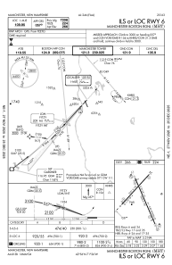
IAC chart of KMHT
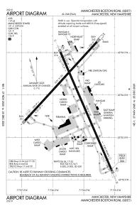
 ADC chart of KMHT
 Satellite view of KMHT
ADC chart of KMHT
Satellite view of KMHT
Sorry, we have no imagery here.
Sorry, we have no imagery here.
Sorry, we have no imagery here.
Sorry, we have no imagery here.
Sorry, we have no imagery here.
Sorry, we have no imagery here.


KMHT - Manchester Boston Rgnl
Located in Manchester, United States
ICAO - MHT, IATA - MHT
Data provided by AirmateGeneral information
Coordinates: N42°55'58" W71°26'9"
Elevation is 266 feet MSL.
Magnetic variation is -15° East View others Airports in New Hampshire
Operational data
Special qualification required
Current time UTC:
Current local time:
Weather
METAR: KMHT 280953Z 20004KT 10SM FEW130 BKN250 02/M07 A3002 RMK AO2 SLP181 T00171072
TAF: KMHT 280919Z 2809/2906 26005KT P6SM SCT100 FM281200 28010G17KT P6SM SCT150 FM282200 28005KT P6SM BKN060
Communications frequencies: [VIEW]
Runways:
| RWY identifier | QFU | Length (ft) | Width (ft) | Surface | LDA (ft) |
| 06 | 42° | 7651 | 150 | ASPH | 7208 |
| 24 | 222° | 7651 | 150 | ASPH | 6850 |
| 17 | 157° | 9250 | 150 | ASPH | 8914 |
| 35 | 337° | 9250 | 150 | ASPH | 7650 |
Airport contact information
Address: Manchester United States
Other aviation service providers
Repair station

Satellite view of KMHT
Sorry, we have no imagery here.
Sorry, we have no imagery here.
Sorry, we have no imagery here.
Sorry, we have no imagery here.
Sorry, we have no imagery here.
Sorry, we have no imagery here.