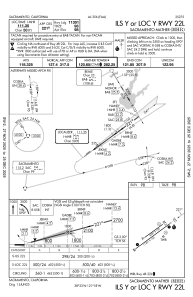
IAC chart of KMHR
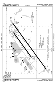
 ADC chart of KMHR
 Satellite view of KMHR
ADC chart of KMHR
Satellite view of KMHR
Sorry, we have no imagery here.
Sorry, we have no imagery here.
Sorry, we have no imagery here.
Sorry, we have no imagery here.
Sorry, we have no imagery here.
Sorry, we have no imagery here.


KMHR - Sacramento Mather
Located in Sacramento, United States
ICAO - MHR, IATA - MHR
Data provided by AirmateGeneral information
Coordinates: N38°33'19" W121°17'50"
Elevation is 98 feet MSL.
Magnetic variation is 13° East View others Airports in California
Operational data
Special qualification required
Current time UTC:
Current local time:
Weather
METAR: KMHR 200955Z AUTO 34010KT 10SM CLR 09/08 A3019 RMK AO2
TAF: KMHR 200625Z 2006/2106 35005KT P6SM SKC TEMPO 2006/2010 1SM BR FM201600 33012G20KT P6SM SCT250 FM210200 31005KT P6SM SKC
Communications frequencies: [VIEW]
Runways:
| RWY identifier | QFU | Length (ft) | Width (ft) | Surface | LDA (ft) |
| 04L | 54° | 6081 | 150 | ASPH | |
| 22R | 234° | 6081 | 150 | ASPH | |
| 04R | 54° | 11301 | 150 | OTHER | |
| 22L | 234° | 11301 | 150 | OTHER | |
| H1 | 0° | 0 | 0 | UNK | |
| H2 | 0° | 0 | 0 | UNK |
Airport contact information
Address: Sacramento United States
Other aviation service providers
Repair station

Satellite view of KMHR
Sorry, we have no imagery here.
Sorry, we have no imagery here.
Sorry, we have no imagery here.
Sorry, we have no imagery here.
Sorry, we have no imagery here.
Sorry, we have no imagery here.