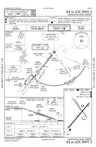
IAC chart of KMHK
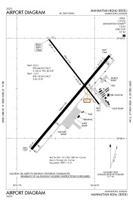
 ADC chart of KMHK
 Satellite view of KMHK

ADC chart of KMHK
Satellite view of KMHK
Sorry, we have no imagery here.
Sorry, we have no imagery here.
Sorry, we have no imagery here.
Sorry, we have no imagery here.
Sorry, we have no imagery here.
Sorry, we have no imagery here.


KMHK - Manhattan Rgnl
Located in Manhattan, United States
ICAO - MHK, IATA - MHK
Data provided by AirmateGeneral information
Coordinates: N39°8'29" W96°40'18"
Elevation is 1066 feet MSL.
Magnetic variation is 04° East View others Airports in Kansas
Operational data
Special qualification required
Current time UTC:
Current local time:
Weather
METAR: KMHK 290652Z AUTO 20008KT 10SM CLR 17/13 A2969 RMK AO2 SLP046 T01720133
TAF: KMHK 290704Z 2907/3006 19009KT P6SM SCT030 FM290800 16010KT P6SM SCT009 OVC013 FM291500 17014G25KT P6SM SCT009 OVC013 FM292000 20014G26KT P6SM SCT025 BKN035 FM300000 30012G22KT P6SM SCT030 BKN050
Communications frequencies: [VIEW]
Runways:
| RWY identifier | QFU | Length (ft) | Width (ft) | Surface | LDA (ft) |
| 03 | 40° | 7400 | 150 | CONC | 7030 |
| 21 | 220° | 7400 | 150 | CONC | 7030 |
| 13 | 142° | 5001 | 75 | OTHER | 5000 |
| 31 | 322° | 5001 | 75 | OTHER | 5000 |
Airport contact information
Address: Manhattan United States
Other aviation service providers
Flight schools

Satellite view of KMHK
Sorry, we have no imagery here.
Sorry, we have no imagery here.
Sorry, we have no imagery here.
Sorry, we have no imagery here.
Sorry, we have no imagery here.
Sorry, we have no imagery here.