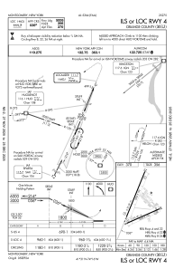
IAC chart of KMGJ
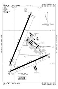
 ADC chart of KMGJ
 Satellite view of KMGJ

ADC chart of KMGJ
Satellite view of KMGJ
Sorry, we have no imagery here.
Sorry, we have no imagery here.
Sorry, we have no imagery here.
Sorry, we have no imagery here.
Sorry, we have no imagery here.
Sorry, we have no imagery here.


KMGJ - Orange County
Located in Montgomery, United States
ICAO - MGJ, IATA - MGJ
Data provided by AirmateGeneral information
Coordinates: N41°30'43" W74°15'49"
Elevation is 370 feet MSL.
Magnetic variation is -14° East View others Airports in New York
Operational data
Special qualification required
Current time UTC:
Current local time:
Weather
METAR: KMGJ 162354Z AUTO 16012G20KT 10SM OVC029 17/12 A2977 RMK AO2 SLP080 T01720122 10194 20172 51006
Communications frequencies: [VIEW]
Runways:
| RWY identifier | QFU | Length (ft) | Width (ft) | Surface | LDA (ft) |
| 04 | 22° | 5006 | 100 | ASPH | |
| 22 | 202° | 5006 | 100 | ASPH | |
| 08 | 66° | 3664 | 100 | ASPH | |
| 26 | 246° | 3664 | 100 | ASPH |
Airport contact information
Address: Montgomery United States
Other aviation service providers
Flight schools

Satellite view of KMGJ
Sorry, we have no imagery here.
Sorry, we have no imagery here.
Sorry, we have no imagery here.
Sorry, we have no imagery here.
Sorry, we have no imagery here.
Sorry, we have no imagery here.