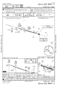
IAC chart of KMGE
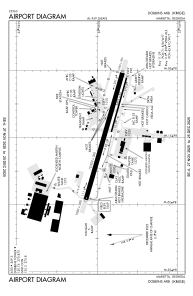
 ADC chart of KMGE
 Satellite view of KMGE
ADC chart of KMGE
Satellite view of KMGE
Sorry, we have no imagery here.
Sorry, we have no imagery here.
Sorry, we have no imagery here.
Sorry, we have no imagery here.
Sorry, we have no imagery here.
Sorry, we have no imagery here.


KMGE - Dobbins Arb
Located in Marietta, United States
ICAO - MGE, IATA - MGE
Data provided by AirmateGeneral information
Coordinates: N33°54'52" W84°30'51"
Elevation is 1068 feet MSL.
Magnetic variation is -03° East View others Airports in Georgia
Operational data
Special qualification required
Current time UTC:
Current local time:
Weather
METAR: KMGE 290555Z AUTO 15006KT 10SM CLR 21/08 A3015 RMK AO2 SLP202 T02050075 10243 20203 58005 $
TAF: TAF KMGE 282100Z 2821/3003 17010G15KT 9999 SCT250 QNH3019INS BECMG 2823/2824 15006KT 9999 SCT150 BKN200 QNH3014INS BECMG 2913/2914 16010G15KT 9999 FEW050 BKN150 QNH3012INS BECMG 2918/2919 16012G18KT 9999 BKN035 BKN150 QNH3005INS BECMG 3001/3002 16010KT 9999 BKN030 BKN100 QNH3006INS TX27/2821Z TN16/2912Z LAST NO AMDS AFT 2903 NEXT 2911
Communications frequencies: [VIEW]
Runways:
| RWY identifier | QFU | Length (ft) | Width (ft) | Surface | LDA (ft) |
| 11 | 106° | 10002 | 300 | CONC | |
| 29 | 286° | 10002 | 300 | CONC | |
| 110 | 106° | 3495 | 60 | CONC | |
| 290 | 286° | 3495 | 60 | CONC |
Airport contact information
Address: Marietta United States
Satellite view of KMGE
Sorry, we have no imagery here.
Sorry, we have no imagery here.
Sorry, we have no imagery here.
Sorry, we have no imagery here.
Sorry, we have no imagery here.
Sorry, we have no imagery here.