IAC chart of KMCC
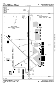
 ADC chart of KMCC
 Satellite view of KMCC
ADC chart of KMCC
Satellite view of KMCC
Sorry, we have no imagery here.
Sorry, we have no imagery here.
Sorry, we have no imagery here.
Sorry, we have no imagery here.
Sorry, we have no imagery here.
Sorry, we have no imagery here.


KMCC - Mc Clellan Airfield
Located in Sacramento, United States
ICAO - MCC, IATA - MCC
Data provided by AirmateGeneral information
Coordinates: N38°40'4" W121°24'2"
Elevation is 76 feet MSL.
Magnetic variation is 17° East View others Airports in California
Operational data
Special qualification required
Current time UTC:
Current local time:
Weather
METAR: KMCC 151655Z AUTO 17012KT 10SM CLR 15/10 A2996 RMK AO2
TAF: KMCC 151128Z 1512/1612 VRB05KT P6SM SKC FM151400 18009KT P6SM BKN250 FM152300 19012G16KT P6SM BKN250
Communications frequencies: [VIEW]
Runways:
| RWY identifier | QFU | Length (ft) | Width (ft) | Surface | LDA (ft) |
| 16 | 180° | 10599 | 150 | CONC | |
| 34 | 360° | 10599 | 150 | CONC | |
| H1 | 0° | 0 | 0 | UNK | |
| H2 | 0° | 0 | 0 | UNK | |
| H3 | 0° | 0 | 0 | UNK | |
| H4 | 0° | 0 | 0 | UNK |
Airport contact information
Address: Sacramento United States
Other aviation service providers
Repair station

Flight schools

Flying Panthers Flight School, Inc
Flying Panthers Flight School, Inc
info@flyingpanthers.org+1(916)400-0330
Satellite view of KMCC
Sorry, we have no imagery here.
Sorry, we have no imagery here.
Sorry, we have no imagery here.
Sorry, we have no imagery here.
Sorry, we have no imagery here.
Sorry, we have no imagery here.