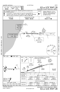
IAC chart of KMBL
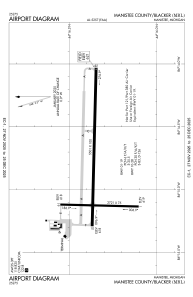
 ADC chart of KMBL
 Satellite view of KMBL
ADC chart of KMBL
Satellite view of KMBL
Sorry, we have no imagery here.
Sorry, we have no imagery here.
Sorry, we have no imagery here.
Sorry, we have no imagery here.
Sorry, we have no imagery here.
Sorry, we have no imagery here.


KMBL - Manistee County/Blacker
Located in Manistee, United States
ICAO - MBL, IATA - MBL
Data provided by AirmateGeneral information
Coordinates: N44°16'21" W86°14'49"
Elevation is 621 feet MSL.
Magnetic variation is -06° East View others Airports in Michigan
Operational data
Special qualification required
Current time UTC:
Current local time:
Weather
METAR: KMBL 281356Z AUTO 06005KT 10SM OVC110 17/08 A3011 RMK AO2 SLP198 T01670083
TAF: KMBL 281120Z 2812/2912 VRB03KT P6SM BKN100 FM281800 07009G17KT P6SM OVC070 FM290000 09005KT P6SM -SHRA OVC050
Communications frequencies: [VIEW]
Runways:
| RWY identifier | QFU | Length (ft) | Width (ft) | Surface | LDA (ft) |
| 01 | 1° | 2721 | 75 | ASPH | 2721 |
| 19 | 181° | 2721 | 75 | ASPH | 2721 |
| 10 | 91° | 5501 | 100 | ASPH | 5501 |
| 28 | 271° | 5501 | 100 | ASPH | 5501 |
Airport contact information
Address: Manistee United States
Other aviation service providers
Flight schools

Satellite view of KMBL
Sorry, we have no imagery here.
Sorry, we have no imagery here.
Sorry, we have no imagery here.
Sorry, we have no imagery here.
Sorry, we have no imagery here.
Sorry, we have no imagery here.