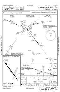
IAC chart of KLXN
 Satellite view of KLXN
Satellite view of KLXN
Sorry, we have no imagery here.
Sorry, we have no imagery here.
Sorry, we have no imagery here.
Sorry, we have no imagery here.
Sorry, we have no imagery here.
Sorry, we have no imagery here.


KLXN - Jim Kelly Fld
Located in Lexington, United States
ICAO - LXN, IATA - LXN
Data provided by AirmateGeneral information
Coordinates: N40°47'26" W99°46'33"
Elevation is 2412 feet MSL.
Magnetic variation is 07° East View others Airports in Nebraska
Operational data
Special qualification required
Current time UTC:
Current local time:
Weather
METAR: KLXN 220935Z AUTO 00000KT 10SM CLR M02/M07 A2992 RMK AO2 T10161071
Communications frequencies: [VIEW]
Runways:
| RWY identifier | QFU | Length (ft) | Width (ft) | Surface | LDA (ft) |
| 01 | 18° | 3200 | 250 | GRASS | |
| 19 | 198° | 3200 | 250 | GRASS | |
| 14 | 143° | 5489 | 100 | CONC | |
| 32 | 323° | 5489 | 100 | CONC |
Airport contact information
Address: Lexington United States
Satellite view of KLXN
Sorry, we have no imagery here.
Sorry, we have no imagery here.
Sorry, we have no imagery here.
Sorry, we have no imagery here.
Sorry, we have no imagery here.
Sorry, we have no imagery here.