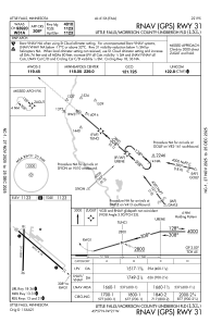
IAC chart of KLXL
 Satellite view of KLXL
Satellite view of KLXL
Sorry, we have no imagery here.
Sorry, we have no imagery here.
Sorry, we have no imagery here.
Sorry, we have no imagery here.
Sorry, we have no imagery here.
Sorry, we have no imagery here.


KLXL - Little Falls/Morrison County-Lindbergh Fld
Located in Little Falls, United States
ICAO - LXL, IATA -
Data provided by AirmateGeneral information
Coordinates: N45°56'57" W94°20'49"
Elevation is 1122 feet MSL.
Magnetic variation is 03° East View others Airports in Minnesota
Operational data
Special qualification required
Current time UTC:
Current local time:
Weather
METAR: KLXL 210807Z AUTO 07005KT 1 3/4SM UP OVC004 05/05 A2981 RMK AO2
Communications frequencies: [VIEW]
Runways:
| RWY identifier | QFU | Length (ft) | Width (ft) | Surface | LDA (ft) |
| 13 | 131° | 4010 | 75 | ASPH | |
| 31 | 311° | 4010 | 75 | ASPH | |
| 18 | 181° | 2858 | 60 | ASPH | 2856 |
| 36 | 1° | 2858 | 60 | ASPH | 2856 |
Airport contact information
Address: Little Falls United States
Satellite view of KLXL
Sorry, we have no imagery here.
Sorry, we have no imagery here.
Sorry, we have no imagery here.
Sorry, we have no imagery here.
Sorry, we have no imagery here.
Sorry, we have no imagery here.