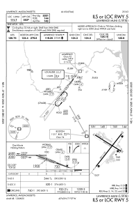
IAC chart of KLWM
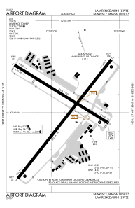
 ADC chart of KLWM
 Satellite view of KLWM
ADC chart of KLWM
Satellite view of KLWM
Sorry, we have no imagery here.
Sorry, we have no imagery here.
Sorry, we have no imagery here.
Sorry, we have no imagery here.
Sorry, we have no imagery here.
Sorry, we have no imagery here.


KLWM - Lawrence Muni
Located in Lawrence, United States
ICAO - LWM, IATA - LWM
Data provided by AirmateGeneral information
Coordinates: N42°43'1" W71°7'25"
Elevation is 147 feet MSL.
Magnetic variation is -15° East View others Airports in Massachusetts
Operational data
Special qualification required
Current time UTC:
Current local time:
Weather
METAR: KLWM 182254Z 27009KT 10SM SCT120 18/11 A2947 RMK AO2 SLP979 T01780106
Communications frequencies: [VIEW]
Runways:
| RWY identifier | QFU | Length (ft) | Width (ft) | Surface | LDA (ft) |
| 05 | 38° | 5001 | 100 | ASPH | |
| 23 | 218° | 5001 | 100 | ASPH | |
| 14 | 122° | 3654 | 100 | ASPH | |
| 32 | 302° | 3654 | 100 | ASPH |
Airport contact information
Address: Lawrence United States
Other aviation service providers
Flight schools

Satellite view of KLWM
Sorry, we have no imagery here.
Sorry, we have no imagery here.
Sorry, we have no imagery here.
Sorry, we have no imagery here.
Sorry, we have no imagery here.
Sorry, we have no imagery here.