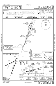
IAC chart of KLUK
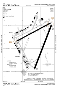
 ADC chart of KLUK
 Satellite view of KLUK
ADC chart of KLUK
Satellite view of KLUK
Sorry, we have no imagery here.
Sorry, we have no imagery here.
Sorry, we have no imagery here.
Sorry, we have no imagery here.
Sorry, we have no imagery here.
Sorry, we have no imagery here.


KLUK - Cincinnati Muni/Lunken Fld
Located in Cincinnati, United States
ICAO - LUK, IATA - LUK
Data provided by AirmateGeneral information
Coordinates: N39°6'11" W84°25'3"
Elevation is 481 feet MSL.
Magnetic variation is -04° East View others Airports in Ohio
Operational data
Special qualification required
Current time UTC:
Current local time:
Weather
METAR: KLUK 210053Z 05004KT 10SM BKN016 OVC049 19/18 A2968 RMK AO2 SLP048 T01940183
TAF: KLUK 202321Z 2100/2124 14006KT P6SM BKN035 FM210100 16006KT P6SM -SHRA OVC028 TEMPO 2101/2104 4SM -TSRA OVC015CB FM210400 16006KT P6SM SCT035 FM211000 23007KT P6SM BKN015 FM211400 25010KT P6SM BKN025 FM211600 25012G20KT P6SM BKN027
Communications frequencies: [VIEW]
Runways:
| RWY identifier | QFU | Length (ft) | Width (ft) | Surface | LDA (ft) |
| 03 | 21° | 6101 | 150 | ASPH | 6101 |
| 21 | 201° | 6101 | 150 | ASPH | 6101 |
| 07 | 62° | 5127 | 100 | ASPH | |
| 25 | 242° | 5127 | 100 | ASPH |
Airport contact information
Address: Cincinnati United States
Other aviation service providers
Flight schools

Satellite view of KLUK
Sorry, we have no imagery here.
Sorry, we have no imagery here.
Sorry, we have no imagery here.
Sorry, we have no imagery here.
Sorry, we have no imagery here.
Sorry, we have no imagery here.