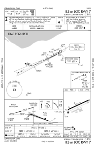
IAC chart of KLPR
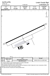
 ADC chart of KLPR
 Satellite view of KLPR
ADC chart of KLPR
Satellite view of KLPR
Sorry, we have no imagery here.
Sorry, we have no imagery here.
Sorry, we have no imagery here.
Sorry, we have no imagery here.
Sorry, we have no imagery here.
Sorry, we have no imagery here.


KLPR - Lorain County Rgnl
Located in Lorain/Elyria, United States
ICAO - LPR, IATA -
Data provided by AirmateGeneral information
Coordinates: N41°20'39" W82°10'40"
Elevation is 793 feet MSL.
Magnetic variation is -08° East View others Airports in Ohio
Operational data
Special qualification required
Current time UTC:
Current local time:
Weather
METAR: KLPR 310453Z AUTO 20011KT 10SM FEW100 FEW120 13/12 A2959 RMK AO2 SLP017 T01330122 401830128 PWINO
Communications frequencies: [VIEW]
Runways:
| RWY identifier | QFU | Length (ft) | Width (ft) | Surface | LDA (ft) |
| 07 | 65° | 5002 | 100 | ASPH | |
| 25 | 245° | 5002 | 100 | ASPH |
Airport contact information
Address: Lorain/Elyria United States
Other aviation service providers
Flight schools

Satellite view of KLPR
Sorry, we have no imagery here.
Sorry, we have no imagery here.
Sorry, we have no imagery here.
Sorry, we have no imagery here.
Sorry, we have no imagery here.
Sorry, we have no imagery here.