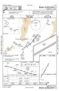
IAC chart of KLOL
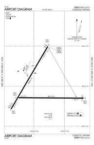
 ADC chart of KLOL
 Satellite view of KLOL
ADC chart of KLOL
Satellite view of KLOL
Sorry, we have no imagery here.
Sorry, we have no imagery here.
Sorry, we have no imagery here.
Sorry, we have no imagery here.
Sorry, we have no imagery here.
Sorry, we have no imagery here.


KLOL - Derby Fld
Located in Lovelock, United States
ICAO - LOL, IATA - LOL
Data provided by AirmateGeneral information
Coordinates: N40°3'59" W118°33'54"
Elevation is 3907 feet MSL.
Magnetic variation is 14° East View others Airports in Nevada
Operational data
Special qualification required
Current time UTC:
Current local time:
Weather
METAR: KLOL 281353Z AUTO 00000KT 10SM CLR M01/M06 A2991 RMK AO2 SLP129 T10061056
Communications frequencies: [VIEW]
Runways:
| RWY identifier | QFU | Length (ft) | Width (ft) | Surface | LDA (ft) |
| 02 | 30° | 5529 | 75 | ASPH | |
| 20 | 210° | 5529 | 75 | ASPH | |
| 08 | 90° | 4931 | 75 | ASPH | |
| 26 | 270° | 4931 | 75 | ASPH |
Airport contact information
Address: Lovelock United States
Satellite view of KLOL
Sorry, we have no imagery here.
Sorry, we have no imagery here.
Sorry, we have no imagery here.
Sorry, we have no imagery here.
Sorry, we have no imagery here.
Sorry, we have no imagery here.