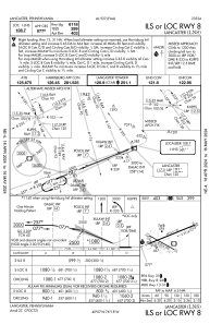
IAC chart of KLNS
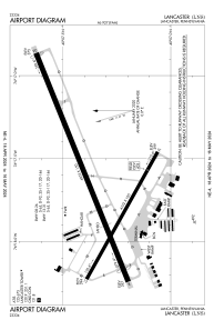
 ADC chart of KLNS
 Satellite view of KLNS
ADC chart of KLNS
Satellite view of KLNS
Sorry, we have no imagery here.
Sorry, we have no imagery here.
Sorry, we have no imagery here.
Sorry, we have no imagery here.
Sorry, we have no imagery here.
Sorry, we have no imagery here.


KLNS - Lancaster
Located in Lancaster, United States
ICAO - LNS, IATA - LNS
Data provided by AirmateGeneral information
Coordinates: N40°7'20" W76°17'40"
Elevation is 402 feet MSL.
Magnetic variation is -09° East View others Airports in Pennsylvania
Operational data
Special qualification required
Current time UTC:
Current local time:
Weather
METAR: KLNS 311953Z 19011KT 10SM SCT060 BKN080 26/14 A2961 RMK AO2 SLP023 T02560139
TAF: KLNS 312030Z 3121/0118 21012G22KT P6SM VCSH BKN050 TEMPO 3121/0101 29020G35KT 1SM +TSRA OVC025CB FM010100 31012G20KT 4SM -SHRA BR OVC025 FM010400 32015G25KT P6SM BKN035 FM011600 33014G22KT P6SM FEW040
Communications frequencies: [VIEW]
Runways:
| RWY identifier | QFU | Length (ft) | Width (ft) | Surface | LDA (ft) |
| 08 | 68° | 6933 | 150 | ASPH | 6118 |
| 26 | 248° | 6933 | 150 | ASPH | 6118 |
| 13 | 119° | 4102 | 100 | ASPH | 4102 |
| 31 | 299° | 4102 | 100 | ASPH | 4102 |
Airport contact information
Address: Lancaster United States
Other aviation service providers
Flight schools

Satellite view of KLNS
Sorry, we have no imagery here.
Sorry, we have no imagery here.
Sorry, we have no imagery here.
Sorry, we have no imagery here.
Sorry, we have no imagery here.
Sorry, we have no imagery here.