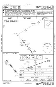
IAC chart of KLNC
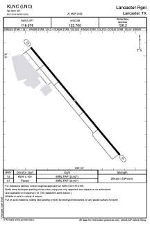
 ADC chart of KLNC
 Satellite view of KLNC
ADC chart of KLNC
Satellite view of KLNC
Sorry, we have no imagery here.
Sorry, we have no imagery here.
Sorry, we have no imagery here.
Sorry, we have no imagery here.
Sorry, we have no imagery here.
Sorry, we have no imagery here.


KLNC - Lancaster Rgnl
Located in Lancaster, United States
ICAO - LNC, IATA -
Data provided by AirmateGeneral information
Coordinates: N32°34'39" W96°43'3"
Elevation is 501 feet MSL.
Magnetic variation is 06° East View others Airports in Texas
Operational data
Special qualification required
Current time UTC:
Current local time:
Weather
METAR: KLNC 252355Z AUTO 15009KT 7SM SCT043 SCT049 SCT055 32/23 A2985 RMK AO2 T03230226 10351 20319
Communications frequencies: [VIEW]
Runways:
| RWY identifier | QFU | Length (ft) | Width (ft) | Surface | LDA (ft) |
| 13 | 140° | 6500 | 100 | ASPH | |
| 31 | 320° | 6500 | 100 | ASPH |
Airport contact information
Address: Lancaster United States
Satellite view of KLNC
Sorry, we have no imagery here.
Sorry, we have no imagery here.
Sorry, we have no imagery here.
Sorry, we have no imagery here.
Sorry, we have no imagery here.
Sorry, we have no imagery here.