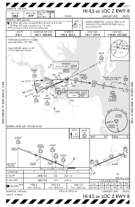
IAC chart of KLFI
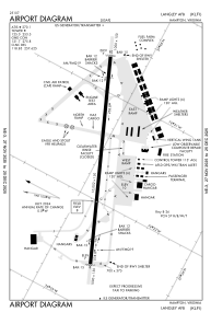
 ADC chart of KLFI
 Satellite view of KLFI
ADC chart of KLFI
Satellite view of KLFI
Sorry, we have no imagery here.
Sorry, we have no imagery here.
Sorry, we have no imagery here.
Sorry, we have no imagery here.
Sorry, we have no imagery here.
Sorry, we have no imagery here.


KLFI - Langley Afb
Located in Hampton, United States
ICAO - LFI, IATA - LFI
Data provided by AirmateGeneral information
Coordinates: N37°4'58" W76°21'38"
Elevation is 8 feet MSL.
Magnetic variation is -10° East View others Airports in Virginia
Operational data
Special qualification required
Current time UTC:
Current local time:
Weather
METAR: KLFI 111711Z 13009G18KT 2SM -RA OVC006 14/13 A2987 RMK AO2A RAB1655E02RAB11 SLP121 CHINO RWY26 $
TAF: TAF KLFI 111700Z 1117/1223 08010G15KT 9000 RA BKN003 OVC008 QNH2987INS BECMG 1118/1119 08012G20KT 4800 +RA SCT003 BKN006 OVC009 QNH2986INS TEMPO 1121/1124 01015G30KT 510002 BECMG 1205/1206 33015G25KT 9000 -RA OVC003 QNH2987INS BECMG 1215/1216 32015G25KT 9999 NSW BKN015 OVC025 QNH2997INS TX15/1119Z TN08/1211Z
Communications frequencies: [VIEW]
Runways:
| RWY identifier | QFU | Length (ft) | Width (ft) | Surface | LDA (ft) |
| 08 | 0° | 10002 | 150 | CONC | |
| 26 | 0° | 10002 | 150 | CONC |
Airport contact information
Address: Hampton United States
Satellite view of KLFI
Sorry, we have no imagery here.
Sorry, we have no imagery here.
Sorry, we have no imagery here.
Sorry, we have no imagery here.
Sorry, we have no imagery here.
Sorry, we have no imagery here.