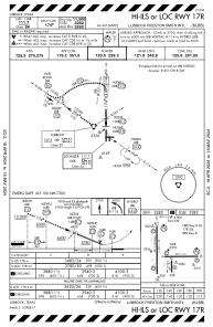
IAC chart of KLBB
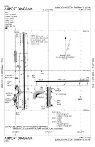
 ADC chart of KLBB
 Satellite view of KLBB

ADC chart of KLBB
Satellite view of KLBB
Sorry, we have no imagery here.
Sorry, we have no imagery here.
Sorry, we have no imagery here.
Sorry, we have no imagery here.
Sorry, we have no imagery here.
Sorry, we have no imagery here.


KLBB - Lubbock Preston Smith Intl
Located in Lubbock, United States
ICAO - LBB, IATA - LBB
Data provided by AirmateGeneral information
Coordinates: N33°39'49" W101°49'14"
Elevation is 3282 feet MSL.
Magnetic variation is 06° East View others Airports in Texas
Operational data
Special qualification required
Current time UTC:
Current local time:
Weather
METAR: KLBB 162253Z 28010G17KT 10SM FEW180 22/M13 A3008 RMK AO2 SLP166 T02171128
TAF: KLBB 162322Z 1623/1724 28011KT P6SM SKC FM171500 22015G25KT P6SM BKN200
Communications frequencies: [VIEW]
Runways:
| RWY identifier | QFU | Length (ft) | Width (ft) | Surface | LDA (ft) |
| 08 | 89° | 8003 | 150 | CONC | 8003 |
| 26 | 269° | 8003 | 150 | CONC | 8003 |
| 17L | 180° | 2891 | 74 | ASPH | 2891 |
| 35R | 360° | 2891 | 74 | ASPH | 2891 |
| 17R | 180° | 11500 | 150 | CONC | 11500 |
| 35L | 360° | 11500 | 150 | CONC | 11500 |
Airport contact information
Address: Lubbock United States
Other aviation service providers
Flight schools

Satellite view of KLBB
Sorry, we have no imagery here.
Sorry, we have no imagery here.
Sorry, we have no imagery here.
Sorry, we have no imagery here.
Sorry, we have no imagery here.
Sorry, we have no imagery here.