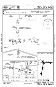
IAC chart of KLAA
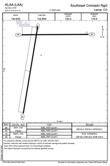
 ADC chart of KLAA
 Satellite view of KLAA
ADC chart of KLAA
Satellite view of KLAA
Sorry, we have no imagery here.
Sorry, we have no imagery here.
Sorry, we have no imagery here.
Sorry, we have no imagery here.
Sorry, we have no imagery here.
Sorry, we have no imagery here.


KLAA - Southeast Colorado Rgnl
Located in Lamar, United States
ICAO - LAA, IATA - LAA
Data provided by AirmateGeneral information
Coordinates: N38°4'11" W102°41'19"
Elevation is 3705 feet MSL.
Magnetic variation is 07° East View others Airports in Colorado
Operational data
Special qualification required
Current time UTC:
Current local time:
Weather
METAR: KLAA 291653Z AUTO VRB06G18KT 10SM CLR 16/04 A2974 RMK AO2 SLP043 T01610044
Communications frequencies: [VIEW]
Runways:
| RWY identifier | QFU | Length (ft) | Width (ft) | Surface | LDA (ft) |
| 08 | 90° | 5001 | 60 | ASPH | |
| 26 | 270° | 5001 | 60 | ASPH | |
| 18 | 190° | 6304 | 100 | CONC | |
| 36 | 10° | 6304 | 100 | CONC |
Airport contact information
Address: Lamar United States
Other aviation service providers
Repair station

Satellite view of KLAA
Sorry, we have no imagery here.
Sorry, we have no imagery here.
Sorry, we have no imagery here.
Sorry, we have no imagery here.
Sorry, we have no imagery here.
Sorry, we have no imagery here.