IAC chart of KJYR
 ADC chart of KJYR
 Satellite view of KJYR
ADC chart of KJYR
Satellite view of KJYR
Sorry, we have no imagery here.
Sorry, we have no imagery here.
Sorry, we have no imagery here.
Sorry, we have no imagery here.
Sorry, we have no imagery here.


KJYR - York Muni
Located in York, United States
ICAO - JYR, IATA -
Data provided by AirmateGeneral information
Coordinates: N40°53'47" W97°37'27"
Elevation is 1669 feet MSL.
Magnetic variation is 06° East View others Airports in Nebraska
Operational data
Special qualification required
Current time UTC:
Current local time:
Weather
METAR: KJYR 190655Z AUTO 11025G30KT 5SM VCTS RA BR SCT005 BKN041 OVC110 14/14 A2961 RMK AO2 LTG DSNT ALQDS P0050
Communications frequencies: [VIEW]
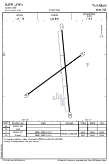
Runways:
| RWY identifier | QFU | Length (ft) | Width (ft) | Surface | LDA (ft) |
| 05 | 54° | 4500 | 150 | GRASS | |
| 23 | 234° | 4500 | 150 | GRASS | |
| 17 | 175° | 5898 | 100 | CONC | 5900 |
| 35 | 355° | 5898 | 100 | CONC | 5500 |
Airport contact information
Address: York United States
Satellite view of KJYR
Sorry, we have no imagery here.
Sorry, we have no imagery here.
Sorry, we have no imagery here.
Sorry, we have no imagery here.
Sorry, we have no imagery here.