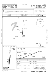
IAC chart of KJWY
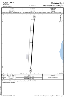
 ADC chart of KJWY
 Satellite view of KJWY

ADC chart of KJWY
Satellite view of KJWY
Sorry, we have no imagery here.
Sorry, we have no imagery here.
Sorry, we have no imagery here.
Sorry, we have no imagery here.
Sorry, we have no imagery here.
Sorry, we have no imagery here.


KJWY - Mid-Way Rgnl
Located in Midlothian/Waxahachie, United States
ICAO - JWY, IATA -
Data provided by AirmateGeneral information
Coordinates: N32°27'30" W96°54'45"
Elevation is 727 feet MSL.
Magnetic variation is 06° East View others Airports in Texas
Operational data
Special qualification required
Current time UTC:
Current local time:
Weather
METAR: KJWY 151435Z AUTO 29010G18KT 10SM SCT003 17/M04 A2949 RMK AO2 T01731044 $
Communications frequencies: [VIEW]
Runways:
| RWY identifier | QFU | Length (ft) | Width (ft) | Surface | LDA (ft) |
| 18 | 184° | 6500 | 100 | ASPH | |
| 36 | 4° | 6500 | 100 | ASPH |
Airport contact information
Address: Midlothian/Waxahachie United States
Satellite view of KJWY
Sorry, we have no imagery here.
Sorry, we have no imagery here.
Sorry, we have no imagery here.
Sorry, we have no imagery here.
Sorry, we have no imagery here.
Sorry, we have no imagery here.