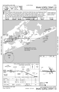
IAC chart of KJPX
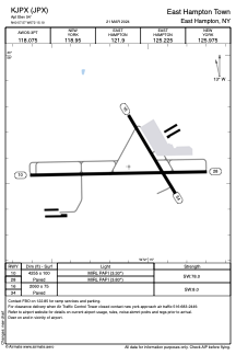
 ADC chart of KJPX
 Satellite view of KJPX
ADC chart of KJPX
Satellite view of KJPX
Sorry, we have no imagery here.
Sorry, we have no imagery here.
Sorry, we have no imagery here.
Sorry, we have no imagery here.
Sorry, we have no imagery here.
Sorry, we have no imagery here.


KJPX - East Hampton Town
Located in East Hampton, United States
ICAO - JPX, IATA -
Data provided by AirmateGeneral information
Coordinates: N40°57'34" W72°15'6"
Elevation is 54 feet MSL.
Magnetic variation is -13° East View others Airports in New York
Operational data
Special qualification required
Current time UTC:
Current local time:
Weather at : KMTP - Montauk ( 31 km )
METAR: KMTP 291254Z AUTO 26007KT 14/08 A2993 RMK AO1 SLP136 T01440078
Communications frequencies: [VIEW]
Runways:
| RWY identifier | QFU | Length (ft) | Width (ft) | Surface | LDA (ft) |
| 10 | 89° | 4255 | 100 | ASPH | |
| 28 | 269° | 4255 | 100 | ASPH | |
| 16 | 149° | 2060 | 75 | ASPH | |
| 34 | 329° | 2060 | 75 | ASPH |
Airport contact information
Address: East Hampton United States
Satellite view of KJPX
Sorry, we have no imagery here.
Sorry, we have no imagery here.
Sorry, we have no imagery here.
Sorry, we have no imagery here.
Sorry, we have no imagery here.
Sorry, we have no imagery here.