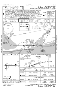
IAC chart of KJKA
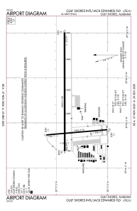
 ADC chart of KJKA
 Satellite view of KJKA

ADC chart of KJKA
Satellite view of KJKA
Sorry, we have no imagery here.
Sorry, we have no imagery here.
Sorry, we have no imagery here.
Sorry, we have no imagery here.
Sorry, we have no imagery here.
Sorry, we have no imagery here.


KJKA - Gulf Shores Intl/Jack Edwards Fld
Located in Gulf Shores, United States
ICAO - JKA, IATA - GUF
Data provided by AirmateGeneral information
Coordinates: N30°17'23" W87°40'18"
Elevation is 17 feet MSL.
Magnetic variation is 00° East View others Airports in Alabama
Operational data
Special qualification required
Current time UTC:
Current local time:
Weather
TAF: KJKA 050531Z 0506/0606 25012G18KT 6SM -RA BR OVC015 FM050700 24015G25KT P6SM SCT040 BKN100 FM051300 27020G30KT P6SM SCT250 FM060200 30014G22KT P6SM FEW250 AMD NOT SKED
Communications frequencies: [VIEW]
Runways:
| RWY identifier | QFU | Length (ft) | Width (ft) | Surface | LDA (ft) |
| 09 | 90° | 6962 | 100 | ASPH | 6500 |
| 27 | 270° | 6962 | 100 | ASPH | 6500 |
| 17 | 175° | 3596 | 75 | ASPH | 3276 |
| 35 | 355° | 3596 | 75 | ASPH | 3276 |
Airport contact information
Address: Gulf Shores United States
Other aviation service providers
Repair station

Resicum International Dba Aeropro
Resicum International Dba Aeropro
phillip@aeroproinflight.com215-200-8521
Flight schools

Satellite view of KJKA
Sorry, we have no imagery here.
Sorry, we have no imagery here.
Sorry, we have no imagery here.
Sorry, we have no imagery here.
Sorry, we have no imagery here.
Sorry, we have no imagery here.