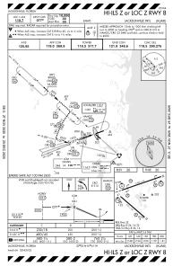
IAC chart of KJAX
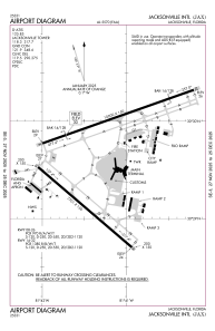
 ADC chart of KJAX
 Satellite view of KJAX
ADC chart of KJAX
Satellite view of KJAX
Sorry, we have no imagery here.
Sorry, we have no imagery here.
Sorry, we have no imagery here.
Sorry, we have no imagery here.
Sorry, we have no imagery here.
Sorry, we have no imagery here.


KJAX - Jacksonville Intl
Located in Jacksonville, United States
ICAO - JAX, IATA - JAX
Data provided by AirmateGeneral information
Coordinates: N30°29'39" W81°41'16"
Elevation is 29 feet MSL.
Magnetic variation is -06° East View others Airports in Florida
Operational data
Special qualification required
Current time UTC:
Current local time:
Weather
METAR: KJAX 170156Z 23007KT 10SM CLR 27/18 A2997 RMK AO2 SLP149 T02670178 $
TAF: KJAX 162322Z 1700/1724 26007KT P6SM SCT250
Communications frequencies: [VIEW]
Runways:
| RWY identifier | QFU | Length (ft) | Width (ft) | Surface | LDA (ft) |
| 08 | 71° | 10000 | 150 | CONC | |
| 26 | 251° | 10000 | 150 | CONC | |
| 14 | 131° | 7701 | 150 | CONC | |
| 32 | 311° | 7701 | 150 | CONC |
Airport contact information
Address: Jacksonville United States
Satellite view of KJAX
Sorry, we have no imagery here.
Sorry, we have no imagery here.
Sorry, we have no imagery here.
Sorry, we have no imagery here.
Sorry, we have no imagery here.
Sorry, we have no imagery here.