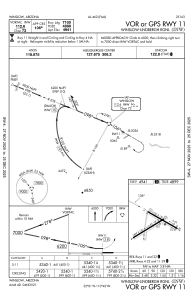
IAC chart of KINW
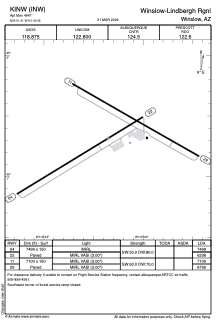
 ADC chart of KINW
 Satellite view of KINW
ADC chart of KINW
Satellite view of KINW
Sorry, we have no imagery here.
Sorry, we have no imagery here.
Sorry, we have no imagery here.
Sorry, we have no imagery here.
Sorry, we have no imagery here.
Sorry, we have no imagery here.


KINW - Winslow-Lindbergh Rgnl
Located in Winslow, United States
ICAO - INW, IATA - INW
Data provided by AirmateGeneral information
Coordinates: N35°1'19" W110°43'21"
Elevation is 4941 feet MSL.
Magnetic variation is 14° East View others Airports in Arizona
Operational data
Special qualification required
Current time UTC:
Current local time:
Weather
METAR: KINW 111956Z AUTO 21007KT 10SM CLR 29/M13 A3016 RMK AO2 SLP149 T02941128
TAF: KINW 111720Z 1118/1218 VRB05KT P6SM FEW250 FM112200 21010G20KT P6SM FEW250 FM120200 23009KT P6SM FEW250 FM120600 14005KT P6SM FEW250
Communications frequencies: [VIEW]
Runways:
| RWY identifier | QFU | Length (ft) | Width (ft) | Surface | LDA (ft) |
| 04 | 59° | 7499 | 150 | ASPH | 7499 |
| 22 | 239° | 7499 | 150 | ASPH | 6236 |
| 11 | 120° | 7100 | 150 | ASPH | 7100 |
| 29 | 300° | 7100 | 150 | ASPH | 6756 |
Airport contact information
Address: Winslow United States
Satellite view of KINW
Sorry, we have no imagery here.
Sorry, we have no imagery here.
Sorry, we have no imagery here.
Sorry, we have no imagery here.
Sorry, we have no imagery here.
Sorry, we have no imagery here.