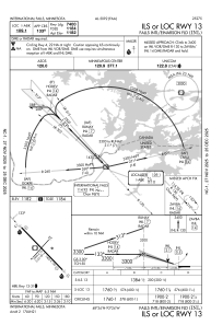
IAC chart of KINL
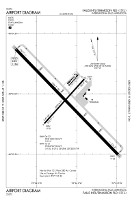
 ADC chart of KINL
 Satellite view of KINL

ADC chart of KINL
Satellite view of KINL
Sorry, we have no imagery here.
Sorry, we have no imagery here.
Sorry, we have no imagery here.
Sorry, we have no imagery here.
Sorry, we have no imagery here.
Sorry, we have no imagery here.


KINL - Falls Intl/Einarson Fld
Located in International Falls, United States
ICAO - INL, IATA - INL
Data provided by AirmateGeneral information
Coordinates: N48°33'56" W93°24'8"
Elevation is 1184 feet MSL.
Magnetic variation is 03° East View others Airports in Minnesota
Operational data
Special qualification required
Current time UTC:
Current local time:
Weather
TAF: KINL 090520Z 0906/1006 VRB04KT P6SM BKN170 FM091300 24007KT P6SM BKN200 FM092000 29011G18KT P6SM SCT250 FM092300 29007KT P6SM SCT230
Communications frequencies: [VIEW]
Runways:
| RWY identifier | QFU | Length (ft) | Width (ft) | Surface | LDA (ft) |
| 04 | 42° | 2999 | 75 | ASPH | 2999 |
| 22 | 222° | 2999 | 75 | ASPH | 2999 |
| 13 | 136° | 7400 | 150 | ASPH | 7400 |
| 31 | 316° | 7400 | 150 | ASPH | 7400 |
Airport contact information
Address: International Falls United States
Satellite view of KINL
Sorry, we have no imagery here.
Sorry, we have no imagery here.
Sorry, we have no imagery here.
Sorry, we have no imagery here.
Sorry, we have no imagery here.
Sorry, we have no imagery here.