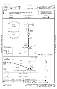
IAC chart of KIIB
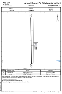
 ADC chart of KIIB
 Satellite view of KIIB
ADC chart of KIIB
Satellite view of KIIB
Sorry, we have no imagery here.
Sorry, we have no imagery here.
Sorry, we have no imagery here.
Sorry, we have no imagery here.
Sorry, we have no imagery here.
Sorry, we have no imagery here.


KIIB - James H Connell Fld At Independence Muni
Located in Independence, United States
ICAO - IIB, IATA -
Data provided by AirmateGeneral information
Coordinates: N42°27'25" W91°56'52"
Elevation is 979 feet MSL.
Magnetic variation is 00° East View others Airports in Iowa
Operational data
Special qualification required
Current time UTC:
Current local time:
Weather
METAR: KIIB 100235Z AUTO 24008KT 10SM CLR 08/03 A2990 RMK AO2 T00770028
Communications frequencies: [VIEW]
Runways:
| RWY identifier | QFU | Length (ft) | Width (ft) | Surface | LDA (ft) |
| 18 | 179° | 5500 | 100 | CONC | |
| 36 | 359° | 5500 | 100 | CONC |
Airport contact information
Address: Independence United States
Other aviation service providers
Flight schools

Satellite view of KIIB
Sorry, we have no imagery here.
Sorry, we have no imagery here.
Sorry, we have no imagery here.
Sorry, we have no imagery here.
Sorry, we have no imagery here.
Sorry, we have no imagery here.